
Dinner and Field Trips
Farewell Dinner (June 25)
Dinner Venue: Círculo Universitário do Porto
Address: Rua do Campo Alegre, nº 877
4150-180 Porto
Field Trip (June 26) – 1 day
On Friday, June 26, 2026, several Field Trips options will be available, allowing participants to discover the diversity and distinctive beauty of some regions in Northern Portugal. Pre-registration is required, as it is not included in the registration fee for the 4th European Rural Geographies Conference.
(PRE-REGISTRATION: not included in the fee)
The participation cost for each visit is €65,00.
– Minimum number of participants – 30
– Maximum number of participants – 50
1 – Please note that the arrival time is approximate and not guaranteed, as it depends on traffic or unforeseen circumstances during the return journey.
2 – Tours will only take place with a minimum of 30 and a maximum of 50 participants.
3 – Your tour booking is only confirmed once payment has been received.
Field Trip 1:
Douro Demarcated Region (Lamego)
Field Trip 2:
Viana do Castelo
Field Trip 1: Douro Demarcated Region (Lamego)
Between terraces and history: landscape, heritage and wines in the Douro Demarcated Region (Baixo Corgo – Lower Corgo)
Coordination:
Helena Pina (CEGOT, Faculty of Arts and Humanities, University of Porto)
Itinerary:
Description:
The Douro Demarcated Region (RDD), one of the most prestigious wine regions in the world, is located in north-eastern Portugal, in the valley of the Douro River and its main tributaries. Institutionalised in 1756, during the period of the Marquis of Pombal, the RDD was the first region to be demarcated and regulated on a global scale. Covering around 250,000 hectares, 40,000 of which are occupied by continuous vineyards, it is divided into three distinct sub-regions in terms of geomorphology, soils and climate, differences that are reflected, of , in the type and quality of the wines produced: DOCs, obviously Port Wine, in addition to sparkling wines.
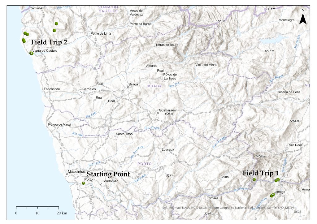
The Douro landscape is undoubtedly a stunning, magnificent setting, marked by a long history that is reflected in an unmistakable landscape, where the mixture of different types of terraces is unmistakable (including traditional terraces, high vineyards and terraced vineyards). Here, there is a marked division of properties, usually delimited by olive trees, portraying a harmonious interaction between human work and nature. This combination led UNESCO to classify the Alto Douro Wine Region (24,600 ha) as a World Heritage Site in 2001, in the category of Evolving and Living Cultural Landscape.
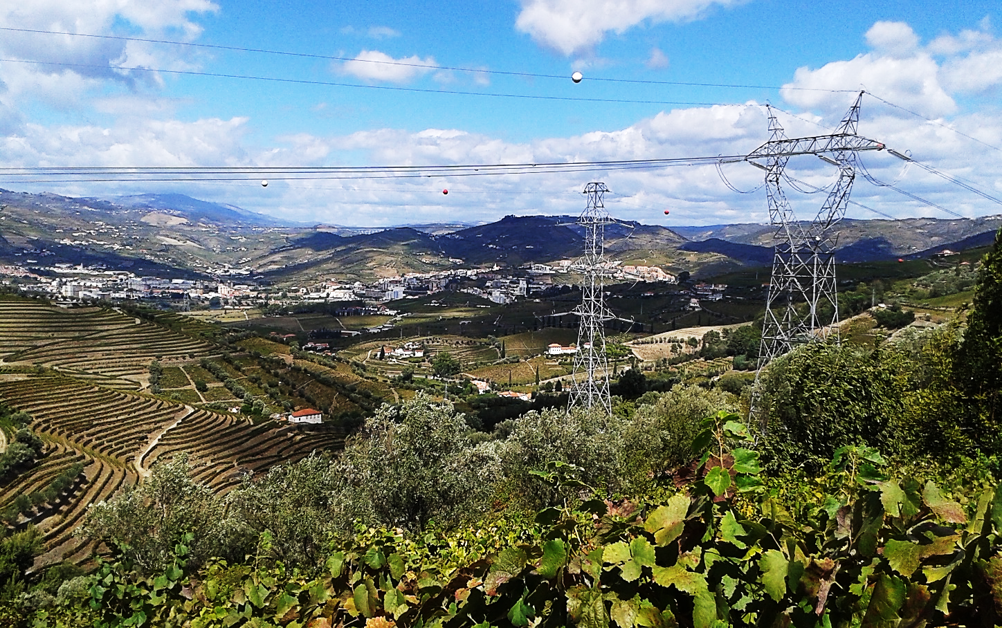
Photo 1 – Typical landscape of the Lower Corgo region of the Douro. (Source: photo by the author, 2025)
In addition to its economic and wine-growing importance, the RDD is home to a superb and diverse architectural, historical and cultural heritage, reflected in the farms, manor houses, churches and urban centres, which bear witness to centuries of wine-growing activity inextricably linked to trade. Centres such as Peso da Régua and the city of Lamego, in addition to the countless farms and their respective manor houses, are illustrative examples of this emblematic Douro heritage. This is the case of Quinta da Pacheca (75 ha), located in Baixo Corgo, one of the oldest and most prestigious, whose history dates back to the 18th century. Today, the estate perfectly combines traditional winegrowing with innovative, high-quality winemaking, as well as olive oil production and renowned wine tourism.
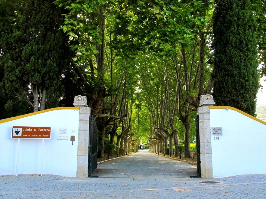
Photo 2 – Entrance to Quinta da Pacheca.
(Source: Quinta da Pacheca archive and website)
Photo 3 – Enjoy an overnight stay in a barrel surrounded by fantastic landscapes.
(Source: Quinta da Pacheca archive and website)
The city of Lamego stands out for its long history, as can be seen from the important role it played in the constitution of Portugal and its independence. In fact, in the 12th century, the first courts of the kingdom met here. With an enviable heritage, highlights include the Cathedral, the Castle and its Keep, and the Sanctuary of Nossa Senhora dos Remédios, built between the 18th and 19th centuries. This architectural ensemble, one of the most notable examples of Baroque religious art in the Douro region, is one of the icons of Lamego, a symbol of the identity of Lamego and the heritage of the Douro Demarcated Region!

This study visit to the Douro Region (Baixo Corgo) provides an understanding of the deep connection between landscape, heritage and wine, as well as the contemporary challenges related to the preservation, sustainability and revitalisation/enhancement of this unique territory, one of the symbols of Portuguese identity and excellence.
Photo 4 – Sanctuary of Nossa Senhora dos Remédios (night view).
(Source: Photo by Paulo Chaves – Facebook.com)
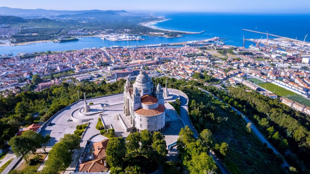
Field Trip 2: Viana do Castelo
From medieval origins to rural traditions: heritage, urban landscape and identity in Guimarães and Fafe
Coordination:
Andreia Amorim Pereira (Municipality of Viana do Castelo)
Support:
Ricardo Carvalhido (Scientific Director of the Aspiring Litoral Geopark of Viana do Castelo)
José Paulo Vieira (Environment and Climate Change Division of the Municipality of Viana do Castelo)
Leontina Cardona and Guilherme Rodrigues (Tourism Unity of the Municipality of Viana do Castelo)
Itinerary:
08:00 AM – Porto (departure)
09:00 AM – Welcome Reception
Official greetings followed by a welcome coffee, featuring a tasting of certified Viana pastries at the Interpretive Center of the Portuguese Coastal Way.
09:30 AM – Historic Center Tour
Guided visit to the historic center of Viana do Castelo, including the Costume Museum.
11:00 AM – Reception at Arga Mountain Observatory
Hosted by the President of the São Lourenço da Montaria Parish Council and the team of the aspiring Viana do Castelo Geopark.
11:30 AM – Visit to Turf of Chãs de Arga
Explore this remarkable geosite within the Viana do Castelo Coastal Geopark.
01:00 PM – Lunch in Montaria Mountain Village
03:00 PM – Documentary Screening: “Fotografia Falada”
04:30 PM – Guided Walk on the Portuguese Coastal Way
Short interpretive walk between Carreço and Afife.
06:00 PM – Wine Tasting
Commented tasting featuring one or more local Viana producers.
07:00 PM – Return to Porto
08:00 PM – Arrival at Porto
Description:
The RuralGeo 2026 study visit in Viana do Castelo offers an integrated reading of a territory where long-term historical processes intersect with highly complex natural dynamics. Between the Atlantic coastline, the Lima River estuary, the agricultural mosaic of the Lima Valley and the granite plateaus of the Arga and Santa Luzia mountain ranges, a deeply human-shaped landscape emerges—yet one that remains structurally conditioned by geology, hydrology, and landform morphology.
The day’s itinerary symbolically follows this altitudinal and ecological transition—from the coast to the valley, and from there to the mountains—providing insight into how different natural systems have supported distinct patterns of human settlement and land use.
1. Historic Centre: Atlantic City, Trade and Pilgrimage
The visit begins at the Interpretive Centre of the Portuguese Coastal Way, housed in “Hospital Velho”, a former pilgrims’ hostel, and continues through Viana do Castelo’s historic centre. Located at the mouth of the Lima River, the city has been, since the Middle Ages, a key hub for trade, pilgrimage and Atlantic connections.
The Costume Museum highlights traditional clothing as an expression of rural society, agricultural economy and regional identity.
2. Lima Valley: Agriculture and River Landscapes
In the lower sector of the Lima River extends the Ribeira Lima, a vast alluvial plain sustaining a millennial agricultural landscape. The system of smallholdings and polyculture, structured upon fertile soils, remains a dominant feature.
The introduction of maize in the 16th century profoundly transformed this landscape, as recorded in the Parish Memories of 1758. The river also functioned as a transport route, enabling the flow of agricultural and fishing products.
Viticulture persists as a structuring element of the Lima Valley landscape. The traditional trellised vine system, delimiting agricultural fields, has evolved into modern training systems. Historic estates and manor houses such as Paço de Anha, Paço de Lanheses and Solar de Louredo stand out in wine production.
Ecologically, the valley is part of the Site of Community Importance and Special Area of Conservation of the Lima River, with riparian galleries and estuarine habitats of high biodiversity value.
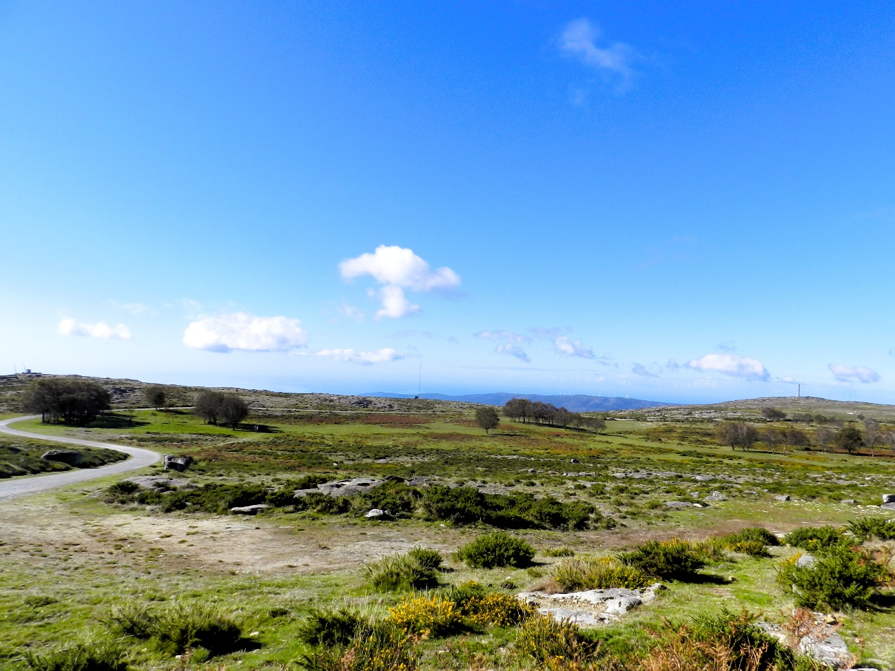
3. Serra de Arga: Geology and Rural Settlement
The late morning leads to the village of Montaria, located on the southern slope of Serra de Arga. It develops between 300 and 400 metres in altitude, at the base of a steep escarpment that defines the central granitic massif. The deposition of sediments resulting from granite erosion creates soils suitable for agriculture, occupied by subsistence farming plots, often supported by terraces.
On the summit plateau (800 m), integrated into the Viana do Castelo Coastal Geopark, peat bogs and heathlands of probable periglacial origin constitute relevant palaeo-environmental records for understanding recent climatic fluctuations.
4. Memory and Lived Landscape
After lunch, the documentary “Fotografia Falada”, produced by AO NORTE, within the framework of the Affective Cartography of Montaria project, will be screened, introducing the intangible dimension of the landscape. Beyond geology, agriculture and history, the territory is also memory, narrative and shared identity.
5. From the Âncora Valley to the Northern Coast: A Dynamic Interface between Land and Sea
The descent from Montaria to the coast crosses the Âncora River valley, which rises in Serra de Arga at 805 metres altitude and flows into Vila Praia de Âncora after a 21 km course, marked by numerous waterfalls and cascades.
On the Atlantic coast, between the Lima estuary and the mouth of the Âncora River, sandy beaches, dune systems and granite cliffs stand out, particularly the Montedor sea cliff, a priority habitat within the Natura 2000 Network. Burial mounds, rock carvings, hillfort settlements, salt-production structures and modern fortifications such as the Fort of Santiago da Barra reveal a continuity of occupation since the Neolithic, associated with marine resources and Atlantic routes.
6. Portuguese Coastal Way – Carreço to Afife Section
In Viana do Castelo, the Camino de Santiago often follows the route of an ancient Roman road, later overlain by the modern “Royal Road”, crossing villages and agricultural areas. The section of the Portuguese Coastal Way between Carreço and Afife develops mainly along old rural paths, crossing cultivated fields, small forest patches and watercourses, with the Atlantic present on the horizon.
After leaving the city, in Areosa, the route passes near Quinta da Boa Viagem and enters a rural landscape structured by stone walls, narrow lanes and traditional paths. The passage through Carreço Parish Church and, in Afife, through São Roque Chapel and the
Cabanas Monastery, marks the continuity of a historical axis connecting spaces of worship, settlement and production.